
Экипаж

Яхта
Lagoon 52F
private owner
Маршрут путешествия
Начало путешествия : Club de Mar de Almería
Выход в море

Club de Mar de Almeria is located within the port of Almeria in Andalusia, Spain. It is a medium capacity Yacht Club with berths for boats and yachts. This marina offers basic services such as water and electricity at their moorings, plus security on pontoons and port area. It also has a slipway with facilities for all kinds of technical work, in which includes one crane, work benches, scaffolding and ladder. Among services available, we mention; pressure hull cleaning, removal and repair of motors,…


День 1 : Boyas de s´Espalmador
Переход: 230.4 NM

A small unihabited island located to the north of Formentera which is characterised by sheletered waters and its revitalising mud baths in the centre of the island.


День 2 : 38°13'21.5''N; 15°14'59.4''E;
Переход: 661.4 NM

Описание стоянки пока остутсвует, но скоро обязательно будет добавлено...
День 3 : 38°54'44.1''N; 17°2'44.1''E;
Переход: 143.5 NM
Описание стоянки пока остутсвует, но скоро обязательно будет добавлено...
День 4 : Argostoli
Переход: 171.5 NM

In Argostólion (Greece), you will find this marina. It includes a range of services available to its customers. . The marina can also provide its customers nautical services which may be of use.
In addition to coming by boat, you can also reach the marina by air, given the short distance between the marina and the nearest airport.


День 5 : 37°57'25.0''N; 22°57'31.8''E;
Переход: 135.5 NM
Описание стоянки пока остутсвует, но скоро обязательно будет добавлено...
День 6 : 37°55'0.0''N; 23°0'32.5''E;
Переход: 3.5 NM
Описание стоянки пока остутсвует, но скоро обязательно будет добавлено...
День 7 : 36°34'27.2''N; 26°23'9.7''E;
Переход: 196.0 NM
Описание стоянки пока остутсвует, но скоро обязательно будет добавлено...
День 8 : Palon
Переход: 38.6 NM
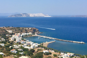
На входе в марину мелко, идите строго по фарватеру. На понтоне есть возможность подключения электричества и воды. Есть несколько контор по прокату авто и мото, в их помещениях можно также принять душ и постирать вещи в стиральной машине. На берегу несколько хороших ресторанов.


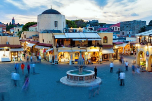
День 9 : Rhodes, Mandraki Port
Переход: 52.1 NM
Описание стоянки пока остутсвует, но скоро обязательно будет добавлено...

День 10 : 36°50'49.5''N; 28°16'56.0''E;
Переход: 25.7 NM
Описание стоянки пока остутсвует, но скоро обязательно будет добавлено...
День 11 : 36°49'29.5''N; 28°18'39.8''E;
Переход: 2.1 NM
Описание стоянки пока остутсвует, но скоро обязательно будет добавлено...